Stoneman Glaciara


- 23:00 h
- 129.70 km
- 4,700 m
- 4,853 m
- 757 m
- 2,455 m
- Difficulty: difficult
- Start: Various starting points possible since it is a circular route
- Destination: Various destination points possible since it is a circular route
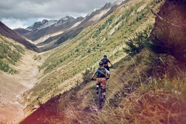
The Stoneman route leads over three balanced stages up to the Aletsch area and back to Mörel. With just under 1600 meters of elevation gain follows the king's ascent: an old military road leads steeply up to the 2451 meter high Breithorn Pass. This is followed by the descent into the Binntal. Always along the Rhone, it then goes towards Obergoms – through ancient, mystical village cores, along historically significant monuments and inviting cafés. The Stoneman Glaciara calls. To adventurous mountain bikers who want to face a very special challenge in an impressive backdrop.

Good to know
Pavements
Best to visit
Directions
Moosfluh - Breithorn
The long descent from Moosfluh via Riederalp and Greich to Mörel requires utmost concentration in places. At several points, short technical sections must be overcome. In the valley floor, the route switches to the shaded side of the Rotten (Rhone) and leads below Bisters over rather flat terrain towards Grengiols. The steep ramp of Grengiols pushes the pulse right up. This is followed by a mostly flat stretch on asphalt towards Breithorn. And here it begins – the Alpe d’Huez of the Stoneman Glaciara. After an endlessly seeming steep ascent (1450 meters elevation gain, 14 hairpin bends) over a military road carved into the mountain during the Second World War, the route climbs the Breithorn Pass, the roof of the Stoneman Glaciara (2451 meters above sea level).
Breithorn - Binn
From here it goes in a long descent (12 kilometers) over a field and gravel road to Heiligkreuz – formerly a much-visited pilgrimage site. The Stoneman Glaciara continues through the Binntal Landscape Park. After a short intermediate ascent, it approaches the village of Binn, the starting point for the hamlet "Im Feld" and the Binntal. The original mountain villages with old houses made of dark larch wood served as accommodation for the "Strahler", who made unique mineral discoveries.
Binn - Reckingen
The first part of the stage runs downhill on the asphalt road. The route turns left onto a bypass of the tunnel. On a paved path, it crosses the impressive, narrow Twingi gorge. Here, the gaze often wanders over the abyss to the Binna stream lying 200 meters below. Another short asphalt section follows before the Stoneman Glaciara continues above Ausserbinn on a beautiful path towards Ernen. Ernen – formerly the ecclesiastical and secular center of the Goms – is the recipient of the Wakker Prize for its particularly well-preserved historic village core. The route now more or less follows the course of the Rotten (Rhone) – upstream via Mühlebach (village core with the oldest wooden houses in Switzerland) – Steinhaus – Bodmen near Blitzingen to Reckingen.
Reckingen - Bellwald
At Reckingen, the Stoneman Glaciara again switches to the sunny side of the high valley. It passes numerous mountain villages (Gluringen, Ritzingen, Biel, Selkingen, Blitzingen), which with their typical, ancient larch houses and compact village cores shape the local cultural heritage. Up to Niederwald, primarily asphalt roads are ridden. In Niederwald, Cäsar Ritz – king of hoteliers and hotelier to kings – grew up. The mountain village has retained its originality and unique charisma. At the village exit begins the tough ascent (300 meters elevation gain) over a fir and larch forest path up to Bellwald.
Bellwald - Märjela
From Bellwald, the sunny terrace of the Goms with a remarkable old village core, the Stoneman Glaciara initially runs rather flat on a mix of road, unpaved path, and trails via the hamlets Ried, Eggen, and downhill to Bodmen. This is followed by the favorite trail of many locals along a glacier end moraine. A wide path interspersed with numerous roots runs through a beautiful forested area. It soon branches right towards the Fieschertal. After a flat section through the villages of Fiesch and Lax, the first challenging climb of about 1200 meters elevation gain begins to Fiescheralp. Once at the top, the route passes the cable car station and leads north towards Märjela – first flat, then with a short climb to the entrance of a tunnel. This adventurous mountain passage (about one kilometer long, cool and sparsely lit) ends right at the Märjela checkpoint.
Märjela - Moosfluh
Märjela, a truly mystical place. Along the ridge where once a glacier lake spread, enchanted souls were said to emerge from the ice at night by legend. Even today, the Aletsch Glacier radiates its magical attraction. A short walk to this spectacular viewpoint is a must. The view of hundreds of meters thick ice and gaping glacier crevasses inspires awe. The route initially runs on narrow paths along the east side of the Eggishorn back to the Fiescheralp. Attention: after a flat approach, a demanding section follows that must be partly pushed. It continues in hilly terrain always following the signage towards Bettmer- and Riederalp. The trails make every mountain biker's heart beat faster. One last steep climb leads the Stoneman Glaciara up to Blausee and further to Moosfluh, which is again rewarded with a unique view of the Great Aletsch Glacier.
Tour information
Cultural Interesting
Loop Road
Stop at an Inn
Equipment
Our recommendation: technically flawless bike, helmet, gloves and bell, clothing suitable for the weather (always with you: rain protection), drink and provisions.
Directions & Parking facilities
Additional information
More information:
Information about the destinations:
Literature
Author´s Tip / Recommendation of the author
Safety guidelines
The mountains, a place of joy to share and respect. The mountain world is a place to meet and experience unforgettable moments together – whether by bike or on foot. For all users to benefit from this, it is essential to share this space with respect towards nature and agriculture. Respectful behavior allows everyone to pursue their leisure activities under the best conditions. Inform yourself about recommendations and rules. Assess your own skills and condition well. Riding the various routes is fundamentally at your own risk.
Map
Nearby


Download GPX file